Back مارساسكالا Arabic Марсаскала BE-X-OLD Marsaskala Catalan Marsaskala (munisipyo) CEB مارساسکالا CKB Marsaskala Czech Marsaskala German Marsaskala Esperanto Marsaskala Spanish Marsaskala Basque
Marsaskala
Wied il-Għajn Marsascala, M'Skala | |
|---|---|
 Marsaskala Bay | |
| Motto: Għajn ta' kenn u mistrieħ | |
 | |
| Coordinates: 35°51′45″N 14°34′3″E / 35.86250°N 14.56750°E | |
| Country | |
| Region | South Eastern Region |
| District | South Eastern District |
| Borders | Marsaxlokk, Żabbar, Żejtun |
| Government | |
| • Mayor | Mario Calleja (PL) |
| Area | |
| • Total | 5.4 km2 (2.1 sq mi) |
| Population (Jan. 2019) | |
| • Total | 14,592 |
| • Density | 2,700/km2 (7,000/sq mi) |
| Demonym | Skali (m) Skalija (f) Skalin (pl) |
| Time zone | UTC+1 (CET) |
| • Summer (DST) | UTC+2 (CEST) |
| Postal code | MSK |
| Dialing code | 356 |
| ISO 3166 code | MT-27 |
| Patron saint | St. Anne |
| Day of festa | Last Sunday of July |
| Website | Official website |
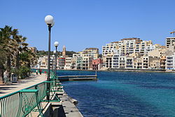
Marsaskala (Maltese: Wied il-Għajn), also written as Marsascala and abbreviated as M'Skala, is a seaside town in the South Eastern Region of Malta which has grown around the small harbour at the head of Marsaskala Bay, a long, narrow inlet also known as Marsaskala Creek. The bay is sheltered to the north by Ras iż-Żonqor, the southeast corner of Malta, and to the south by the headland of Ras il-Gżira. The parish church, built in 1953, is dedicated to Saint Anne and the feast is celebrated at the end of July in Marsaskala.
It was originally a fishing village only but has gradually evolved into a tourist destination and a permanent hometown for an ever-growing population.[1] The town has a winter population of 12,134 people as of March 2014, but swells to around 20,000 in summer.[2]
- ^ Young, Bruce (March 1983). "Touristization of traditional Maltese fishing-farming villages: A general model". Tourism Management. 4 (1). Elsevier Ltd: 35–41. doi:10.1016/0261-5177(83)90048-1.
- ^ "Estimated Population by Locality 31st March, 2014". Government of Malta. 16 May 2014. Archived from the original on 21 June 2015.
© MMXXIII Rich X Search. We shall prevail. All rights reserved. Rich X Search

